Christian Heilmann

Posts Tagged ‘geoip’

Finding the current location by IP and with the W3C Geo API

Monday, January 25th, 2010

I was always fascinated by those ads that show you “hot contacts in {city}” not because of the hot contacts, but because they always changed to where I was at the time.

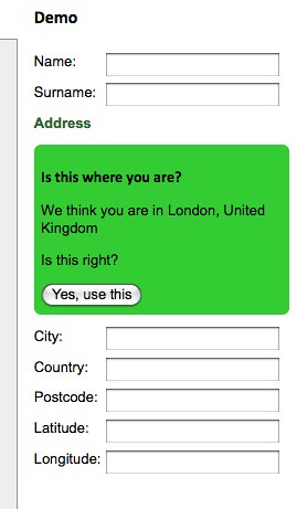
I was also quite interested in the fact that they were always a bit off (again, the city, not the contacts). As I like to find things out, here’s a demo of just how far the location of these ads can be off:

The difference between IP location and Geo location by  you.

You can see your results by visiting the demo page and allowing it to get your location if you use a browser that supports the W3C geo location API.

Here’s how this works:

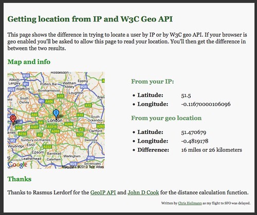
You can guess the location of a user by their IP and Rasmus Lerdorf wrote a nice API to do that at http://geoip.pidgets.com/. Using that, you can read the IP in PHP and call the API with cURL:

if ($_SERVER[‘HTTP_X_FORWARD_FOR’]) {
$ip = $_SERVER[‘HTTP_X_FORWARD_FOR’];
} else {
$ip = $_SERVER[‘REMOTE_ADDR’];
}

$url = ‘http://geoip.pidgets.com/?ip=’.$ip.’&format=json’;
$ch = curl_init();
curl_setopt($ch, CURLOPT_URL, $url);
curl_setopt($ch, CURLOPT_RETURNTRANSFER, 1);
$output = curl_exec($ch);
curl_close($ch);
$data = json_decode($output);
$lat = $data->latitude;
$lon = $data->longitude;

This API is only a wrapper for the Maxmind API and for some reason rounds the latitude and longitude from time to time. You can get more accurate results using the Javascript Web Service of Maxmind directly:


The most detailed data can be obtained with the W3C Geo API though:

if(navigator.geolocation){
navigator.geolocation.getCurrentPosition(function(position){
var lat = position.coords.latitude;
var lon = position.coords.longitude
});
}

And that is all there is to it :)

Postcode from latitude and longitude or even IP – fun with Geo APIs and YQL

Tuesday, June 9th, 2009

One of the more complex things about GeoFill was to get postcode information from an IP. However with a collection of APIs and a collated YQL statement even this was possible.

The first thing I needed to get was the IP of the user. This is done with the GeoIP API based on the GeoLite API from MaxMind. This is available as an open table in YQL and can be used thus:

select * from ip.location where ip=”“

Try the lookup in the console or check the lookup result

Response”: {
“Ip”: “216.39.58.17”,
“Status”: “OK”,
“CountryCode”: “US”,
“CountryName”: “United States”,
“RegionCode”: “06”,
“RegionName”: “California”,
“City”: “Sunnyvale”,
“ZipPostalCode”: “94089”,
“Latitude”: “37.4249”,
“Longitude”: “-122.007”,
“Gmtoffset”: “-8.0”,
“Dstoffset”: “-7.0”
}

This gives us a lot of information. What’s really important here is latitude and longitude, as this can be used in the flickr.places API to get a where on earth ID which is a much more defined identifier:

select * from flickr.places where (lat,lon) in (
select Latitude,Longitude from ip.location where ip=””
)

Try the flickr places call in the console or check the flickr result

“places”: {
“accuracy”: “16”,
“latitude”: “37.4249”,
“longitude”: “-122.007”,
“total”: “1”,
“place”: {
“latitude”: “37.371”,
“longitude”: “-122.038”,
“name”: “Sunnyvale, California, United States”,
“place_id”: “P_ls_fybBJwdHP8t”,
“place_type”: “locality”,
“place_type_id”: “7”,
“place_url”: “/United+States/California/Sunnyvale”,
“timezone”: “America/Los_Angeles”,
“woeid”: “2502265”
}

}


Here the interesting part is the woeid which we can use to dig deeper into geo.places:

select * from geo.places where woeid in (
select place.woeid from flickr.places where (lat,lon) in (
select Latitude,Longitude from ip.location where ip=””
)

)

Try the geo places call in the console or check the geo places result

The result is all the information you’d ever want.

“place”: {
“lang”: “en-US”,
“xmlns”: “http://where.yahooapis.com/v1/schema.rng”,
“yahoo”: “http://www.yahooapis.com/v1/base.rng”,
“uri”: “http://where.yahooapis.com/v1/place/28751237”,
“woeid”: “28751237”,
“placeTypeName”: {
“code”: “22”,
“content”: “Suburb”
},
“name”: “Fairgrounds”,
“country”: {
“code”: “US”,
“type”: “Country”,
“content”: “United States”
},
“admin1”: {
“code”: “US-CA”,
“type”: “State”,
“content”: “California”
},
“admin2”: {
“code”: “”,
“type”: “County”,
“content”: “Santa Clara”
},
“admin3”: null,
“locality1”: {
“type”: “Town”,
“content”: “San Jose”
},
“locality2”: {
“type”: “Suburb”,
“content”: “Fairgrounds”
},
“postal”: {
“type”: “Zip Code”,
“content”: “95112”
},
“centroid”: {
“latitude”: “37.326611”,
“longitude”: “-121.878441”
},
“boundingBox”: {
“southWest”: {
“latitude”: “37.275379”,
“longitude”: “-121.89254”
},
“northEast”: {
“latitude”: “37.330879”,
“longitude”: “-121.808723”
}

}
}

Adding address information automatically to forms with GeoFill

Sunday, June 7th, 2009

One of the things I mentioned in my latest talk and the follow-up Q&A at Gumtree was that I am very interested in Geolocation and automatically detecting the user’s location to save them having to enter all the same info over and over again. Sure, location services like Fire Eagle and autofill options in browsers already do these kind of things, but they are power user toys for now.

Using Rasmus Lerdorf’s GeoIP, YQL and Yahoo Geo I’ve put together a small JavaScript wrapper that does exactly this for you:

GeoFill - automatically filling form data with geo information by  you.

GeoFill (also available on GitHub) allows you to use two different methods to automatically fill forms with geo information:

  • geofill.find(properties) does an IP lookup of the current user and tries to get the geographical data from that one.
  • geofill.lookup(properties,postcode) tries to get the geographical data from the postcode provided in your form.

Both methods take an object which lists the form field IDs to be filled as the parameter. The data returned is city, country, postcode, latitude and longitude.

Both methods also allow you to define a callback function to handle errors or re-use the data in other ways than filling form fields.

For example to get the information connected with a post code you could simply do the following:

geofill.lookup(
{

callback:function(o){
console.log(o);
}

},’wc2h8ad’);

The returned object is:

{
city:”London”,
country:”United Kingdom”,
latitude:”51.51384”,
longitude:”-0.12857”,
postcode:”WC2H 8AD”
}

Useful? In any case it made me play more with the Geo API. Don’t forget that on the 7th of July I’ll be giving a free Tech Talk on Yahoo Placemaker where this will be one of the demos (probably, knowing myself I’ll have hacked other stuff by then). You can sign up for the tech talk on upcoming.